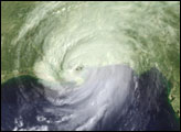
Hurricane Katrina
Hurricane Katrina was the hurricane that hit southeast Louisiana and southern Mississippi at around 6 a.m on Monday, August 29, 2005, as an "extremely dangerous" Category 4 storm.
"With winds of 135 miles per hour (217 kilometers per hour), a powerful storm surge, and heavy rains, Katrina pounded the U.S. Gulf Coast, triggering extensive life-threatening flooding," NASA reported. [1] As Katrina moved over the land during the day it rapidly weakened to be a Catgroy 2 storm by 2.45pm that afternoon.
Preliminary estimates are that as many as one million people could become homeless as a result of the storm [2]. Currently, five million people are without power in the Gulf Coast of the United States region and it may be up to two months before all power is restored [3].
Contents
Maps
"The Google Earth team is working on adding imagery of the impact of Hurricane Katrina ... and will be posting links to this imagery for viewing as 'image overlays' in Google Earth." [4]
Photos
- Hurricane Katrina photos, The Times-Picayune, August 28, 2005 to ....
Timelines
- Katrina Timeline posted at Think Progress website.
- The Katrina Timeline, August 25, 2006.
Related SourceWatch Resources
Hurricane Katrina specific
- FEMA relief spending in pre-Election Florida 2004
- George W. Bush: Hurricane Katrina
- George W. Bush: Hurricane Katrina: Announcements and Press & News Releases
- George W. Bush: Hurricane Katrina: Questions, Criticism and Commentary
- George W. Bush: Hurricane Katrina: Public Relations
- Climate change and Hurricane Katrina
- Hurricane Katrina: Blaming the Victims
- Hurricane Katrina: Crisis in New Orleans
- Hurricane Katrina: Death Toll
- Hurricane Katrina: Disaster Predicted
- Hurricane Katrina: Disaster Relief
- Hurricane Katrina: Environmental Pollution & Contamination
- Hurricane Katrina: Evacuees
- Hurricane Katrina: FEMA
- Hurricane Katrina: Flood Control and Preparedness
- Hurricane Katrina: Gas and Oil Shortage
- Hurricane Katrina: International Aid
- Joint Task Force Katrina
- Hurricane Katrina: Long-term Issues
- Hurricane Katrina: Martial Law
- Hurricane Katrina: National Guard
- Hurricane Katrina: preparedness failure
- Hurricane Katrina: Profiteering
- Hurricane Katrina: Status Reports
- Hurricane Katrina: Unfolding Events
- Hurricane Katrina: Weather Warnings
- Hurricane Katrina: Who's at Fault?
Other SourceWatch pages
External links
- "The Saffir-Simpson Hurricane Scale", National Weather Service, accessed September 2005.
- "Hurricane Katrina", Wikipedia.
- "Katrina weaker but packing a punch", CBC News, August 29, 2005.
- Mark Wallheiser, "Hurricane Katrina brings death, floods to U.S. Gulf", Yahoo News, August 30, 2005.
- "Brace for More Katrinas, Say Experts," Agence France Presse (Truthout), August 30, 2005.
